Why are East Asian “Kuroshio” cyclones frequent in spring? – Mechanisms that bring about the distinct seasonality
Why do East Asian “Kuroshio” cyclones become more frequent in “early spring” rather than “midwinter”?
Cyclones (low-pressure systems) that move eastward significantly affect Japan’s weather. Among them, cyclones moving along the Kuroshio south of the main island of Japan (known as “South-Coast Cyclones” in Japan) sometimes bring heavy rain or even snow to the urban areas on the Pacific side, where the population and industries are heavily concentrated. For instance, the two cyclones that caused disaster due to heavy snow in the Kanto region in February 2014 are typical examples.
Previous research has shown that the activity of such “Kuroshio” cyclones in East Asia becomes most active in early spring (February to April), rather than in mid-winter (January). (Note: For brevity, this article calls the period from February to April, when cyclone activity is particularly active, “spring”.)
However, the fundamental mechanism of “why the cyclone activity peaks in spring, not in mid-winter or autumn,” remains unclear.
In this study, we tackled the challenge by objectively tracking cyclones using observational data and conducting computer simulations.
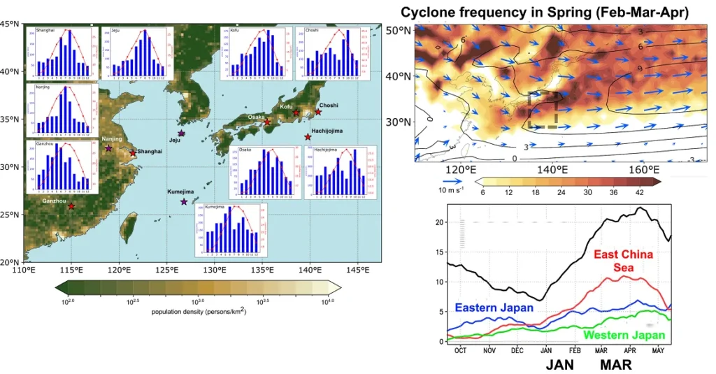
(Left) Seasonal variations in precipitation and temperature, and population density (color, persons/km²) in various cities in East Asia. Red: Cities where precipitation peaks in March. Purple: Cities where precipitation increases in March. This indicates that the peak of rain (or snow) is observed in spring in many East Asian cities.
(Upper Right) Frequency of cyclones in spring (February–April). Blue arrow: Wind at approximately 1,500m above ground (low-level wind flow). Black lines: Wind speed (wind strength), indicating the existence of a local maximum of the wind speed (called a low-level jet stream). Dashed box: The area that “Kuroshio” cyclones in this study pass through.
(Lower Right) Seasonal variation in the “Kuroshio” cyclone frequency. The frequency peaks toward spring.
The key to the spring peak – the development of the low-level jet stream
The analysis revealed that an important factor for the increase in “Kuroshio” cyclones in spring is the higher frequency of cyclone generation around the East China Sea during spring (Fig. 1, Right).
Furthermore, this spring increase in cyclone generation is closely related to the strengthening of the low-level jet stream around the East China Sea and South China.
As the low-level jet stream develops toward spring, a greater number of atmospheric fronts—boundaries where air temperature and properties differ—forms around the East China Sea. Cyclones tend to generate easily along these fronts.
Mechanisms – seasonal continental warming reinforces the low-level jet stream
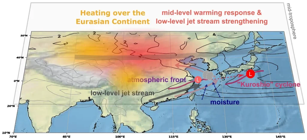
To further investigate “why the low-level jet stream develops in spring”, we conducted simulations using a simplified atmospheric model. Those simulations revealed the following mechanism:
- Continental Warming (Winter to Spring): From winter to spring, the Eurasian Continent is warmed by solar radiation (orange area in Fig. 2).
- Advection by the Upper-Level Wind: This warmed air rides on the large-scale westerly wind in the upper-level (the thin, bold arrow moving from west to east in Fig. 2), and the upper-level atmosphere in the downstream, around the East China Sea, is also warmed (red area in Fig. 2).
- Jet Stream Develops and Front Formation: In response to this upper-level warming, a large-scale air circulation (the two thin pink counter-clockwise arrows in Fig. 2) is induced in the low-level, causing the low-level jet stream to develop around the East China Sea (thin gray arrows and black lines in Fig. 2).
- Cyclone Generation and Development: More fronts (purple line in Fig. 2) form associated with the developed low-level jet stream, and cyclones (red circle ‘L’ in Fig. 2) are more likely to generate along them. These cyclones develop while gaining moisture from the south (navy dashed line in Fig. 2) to move along the Kuroshio, bringing about the spring peak in their frequency.
This study has revealed the mechanisms for why the “Kuroshio” cyclones, which significantly impacts the society and economy of East Asian countries, becomes more frequent in spring. Our findings serves as an important foundation for improving the accuracy of seasonal forecasts in East Asia and understanding how future climate change (global warming) will affect East Asian countries. We plan to investigate the predictability of “Kuroshio” cyclone activity through oceanic variability and future changes in their activity.
For more details:
Okajima S., H. Nakamura, A. Kuwano-Yoshida, and R. Parfitt (2025): Mechanisms for an Early Spring Peak of Extratropical Cyclone Activity in East Asia. Journal of Climate, 38, 1981–1997, doi:10.1175/JCLI-D-24-0203.1.
(Satoru Okajima@A01-3, ECHOES. November 2025)