Decreasing Oyashio water east of Japan
The Oyashio is one of the ocean currents flowing around Japan (Fig. 1). It flows southwestward along the Kuril Islands, transporting cold, fresh, and nutrient-rich seawater (hereafter, Oyashio water) to the region off Hokkaido and Tohoku. The Oyashio water is a source of productive marine ecosystem and abundant fisheries resources in this region.
The Oyashio and its northern origin, the East Kamchatka Current, are a part of a large-scale wind-driven circulation. The strength of these currents is related to sea surface wind over the North Pacific. In response to the seasonal change of sea surface wind, the Oyashio intensifies in winter, and then intrudes significantly into the region off Hokkaido/Tohoku in spring.
In recent years, an anomalous situation occurs off Hokkaido/Tohoku. Catches of saucy and squid, which had been in abundance before, have been extremely poor. This may be attributable to an ocean environment change such as shrinkage of the Oyashio water distribution. To understand backgrounds of the recent anomalous situation off Hokkaido/Tohoku, we have investigated long-term changes of the Oyashio water distribution east of Japan.

We firstly developed a method to analyze a long-term change of the Oyashio water distribution east of Japan. Using this method, we analyzed a high-resolution reconstructed historical ocean dataset produced by the Meteorological Research Institute (MRI) and the Japan Agency for Marine-Earth Science and Technology (JAMSTEC). With a focus on spring (March−May) when the Oyashio significantly intrudes into off Hokkaido/Tohoku, we found that the Oyashio water distribution east of Japan fluctuates interannually and has shrunk significantly over the period of 1982−2016.

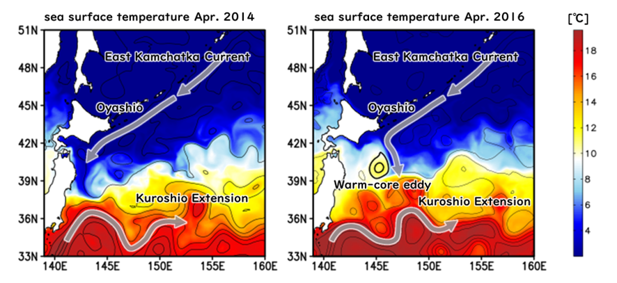
Causes of the Oyashio water distribution change were also examined. We found that clockwise ocean eddies with a diameter of 200-300 km (hereafter called warm-core eddies) play an important role. The warm-core eddies are formed by being detached from meanders of the Kuroshio Extension. In years when a warm-core eddy is located off Hokkaido/Tohoku, the eddy blocks the Oyashio and forces it to veer southeastward, preventing the Oyashio water from spreading toward the east coast of Japan (Fig. 3). In recent years, warm-core eddies are located off Hokkaido/Tohoku more frequently than before, resulting in the Oyashio water distribution shrinkage. This is related to the Kuroshio Extension having two path states: the stable state with steady paths and inactive eddy detachment and the unstable state characterized by meandering paths and frequent eddy shedding. Temporal changes of the Oyashio water distribution would be linked to the Kuroshio Extension path state change.
The strength of the Oyashio and the East Kamchatka Current also affect the Oyashio water distribution east of Japan. The stronger these currents are, the wider the Oyashio water spreads. Our analysis clarified similar features. Furthermore, our investigation revealed that a long-term change of sea surface wind over 1982−2016 causes a weakening of the East Kamchatka Current. Therefore, in addition to increased warm-core eddies, the weakening of the East Kamchatka Current would be a cause of the decreased Oyashio water distribution east of Japan.
The area off Hokkaido/Tohoku is one of the most famous fishing grounds around the world. Abundant fisheries resources in this region are brought by the Oyashio. However, the ocean environment is now changing. Continuous monitoring and further investigation of the Oyashio are needed to answer the question “Will abundant fisheries resources persist as a basis of survival for those of us living in Japan in the future?”.
For more details:
Kawakami, Y., H. Nakano, L. S. Urakawa, T. Toyoda, K. Aoki, N. Hirose, and N. Usui (2025): Temporal changes of the Oyashio water distribution east of Japan under the changing climate: development of an objective evaluation method and its application. Journal of Oceanography, 81, 5–21, doi:10.1007/s10872-024-00727-7.
(Yuma Kawakami@A03-7. August 2024)